Memorial Avenue links Christchurch International Airport with the city via the suburb of Burnside. It was officially opened by Governor General Viscount Cobham on 26 November 1959 as a memorial to air service personnel who died during World War 2.
Burnside origins
Burnside was named because of the small creeks comprising the headwaters of the Waimairi Stream; it is the Scottish name for "by the side of small stream". Much of the area which is now Avonhead and Burnside was originally farm land owned by William Boag (1824-1898). He farmed 1700 acres ( 700 hectares) and a water tower now stands in Burnside Park where his house was, surrounded by the trees his family planted.
Burnside Road
In 1952 the Waimairi County Council was faced with the problem of what to do with Burnside Road. It was still almost a country road, extending from Fendalton Road, through farm land, past the rural Russley Golf Course to Harewood. However it was the entrance to Christchurch from the north and also the route to the airport. As early as 1945, when Burnside Road was a gravel road running through farmland, the idea of a memorial to all airmen killed in the war had been suggested, but it was not until the 1950s that formal planning began.
Joint councils project
Realising that the project was too big for Waimairi alone, the Chairman of the council, William Walter Laing, called a combined meeting of the Christchurch City Council, Paparua County Council and the Main Highways Board, plus the Waimairi County Council. (Riccarton Borough Council and Heathcote County Council were later contributors to the cost of the road development). All agreed that the road should become a worthwhile approach to Christchurch International Airport and also a memorial to members of the Armed Forces.
Costs and compensation
By October 1952, the Burnside Road Memorial Committee was formed with William Laing as chairman. Its first task was to agree on a cost - £135,000 pounds. This cost was then submitted to the Main Highways Board. It was not until 1955 that an independent land valuer was appointed to value the land needed to be taken for road widening and to assess compensation. Residents were told that the committee would either buy their road frontages or obtain them under the Public Works Act, which provided for compensation for land taken and re-erection of fences on the new boundary line. Eighty-six property owners had to be approached along Burnside Road. Forty-four agreed to the land being taken subject to proper compensation being paid, four made direct objections, and the other 33 did not reply.
Entrance to the city
The new avenue was intended to be an attractive entrance to the city. A median strip from Greers Road was planned to make the road more like an avenue. It would be planted with plots of trees, shrubs and grass. After considerable debate about costs, underground wiring was included. There were problems outside the Russley Golf Course: the 16th fairway would have to be altered and some 30-year-old shelter belt trees removed. No provision was made for cycle tracks as it was felt they would narrow the road and make it more dangerous, and would detract from the appearance of the avenue.
By 1956 the plan was finalised. Burnside Road was to be widened from Clyde Road to the airport, a distance of three miles (4.8km). The estimated cost had increased to £155,000 and the scheduled date of completion was 1959. Engineers for the project were H.G. Royds & Sutherland.
Debate over name
On 14 December 1956, the Christchurch Press reported the decision by the Waimairi County Council to adopt the name Burnside Memorial Avenue. The council’s town-planning committee recommended the adoption of the designation "Memorial Avenue" as suggested by the Burnside Road Memorial Committee, but this drew objections from several councillors. Councillor Peter Wynn-Williams felt it was a meaningless name and would be objected to by the public. Other councillors felt that the name of other things in Burnside Road - such as the school - might have to be changed. These fears proved groundless and within months the name Burnside Road had disappeared. To many people the name was associated with the farm that had been subdivided for roading and housing development.
Traffic diverted
During the reconstruction traffic was diverted from some areas so that excavation and laying of the new road could progress quickly and safely. The road works were reported frequently in the Christchurch Press, often illustrated with aerial photographs.
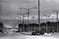
On 12 August 1959, the Press reported Christchurch people would soon see "the fruition of a magnificent concept which has been under consideration and under construction for so long". Already the avenue was a drawcard for sightseers; with hundreds on Sunday afternoon outings. The Press opined that Memorial Avenue would become best known as the jet-age entrance drive from the Christchurch International Airport to the city proper.
Plaques preferred
Miles Warren submitted plans for a large memorial 120ft high (36.58m). This idea was rejected as too costly, and the fear that motorists would be distracted. Instead two plaques were installed, one on the median strip at the Greers Road intersection, the other at the entrance to Christchurch Airport.
Official opening
On 26 November 1959 Governor General Viscount Cobham dedicated the new road to the memory of Christchurch men and women who had lost their lives in Dominion and allied armed services during World War II. Many of these people had trained at Harewood Airport before going overseas. Five Vampire jet fighters from Ohakea saluted the opening in a high speed run at low level.
The Minister of Defence, Mr Phillip Connolly (1899-1970), and the Bishop of Christchurch, the Rt Rev Alwyn Keith Warren also took part in the opening ceremony, together with representatives of the three armed forces. A guard of honour comprising 100 men from Wigram was inspected by Lord Cobham. The chairman of the Burnside Road Memorial Highway Committee, Mr Laing, appealed to users of the avenue to think at least once as they passed along it that it was a memorial. He said the avenue of trees should be regarded as a symbol of life.
Sources:
- “Russley Golf Course boundary trees to go”, The Press 2 October 1954, p 8
- "Harewood Airport: Growth of housing may cause problem", The Press, 20 November 1954, p 6
- "Burnside Road highway", The Press, 20 November 1954, p 9
- "Burnside Road highway", The Press, 26 August 1955, p 13
- “Burnside Road: Change of name to Memorial Avenue", The Press, 14 December 1956, p 16
- "Memorial Avenue bicycle decision endorsed", The Press, 11 December 1957, p 12
- "Memorial Avenue", The Press, 14 June 1958, p 12
- “Progress on Memorial Avenue is shown in this aerial photograph looking towards Cashmere Hills. Part of the Russley Golf is in the left foreground”, The Press, 20 September 1958, p 13
- “Memorial Avenue looking towards Fendalton, with the Russley Golf Course at bottom left”, The Press, 13 July 1959, p 13
- “Memorial Avenue contract nearly completed”, The Press, 12 August 1959, p 23
- "Ceremonial opening of Memorial Avenue", The Press, 19 November 1959, p 22
- “The opening and dedication of Memorial Avenue”, The Press, 27 November 1959, p 7
- “Memorial Avenue opened: Governor-General unveils plaque”, The Press, 27 November 1959, p 8
- "Obituary: Mr W. W. Laing", The Press, 16 November 1968, p 14
- Hopwood, Malcolm. Waimairi life. Christchurch, N.Z.: Waimairi District Council, 1989
- Living with the past: historical buildings of the Waimairi District. Christchurch, N.Z.: Waimairi District Council, 1988
- Penney, Sarah E.W. Beyond the city: the land and its people, Riccarton, Waimairi, Paparua. Christchurch: Penney Ash Publications, c1977
- Rt Rev Alwyn Keith Warren from the New Zealand Dictionary of Biography.