Mānuka was the name of a large Ngāti Māmoe pā that stood at the foot of the hills not far from Tai Tapu.
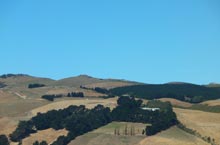 The pā was situated in a strong defensive position but this proved no hindrance to Ngāi Tahu chief Te Rakiwhakaputa who stormed and captured the pā during his rampage of the Whakaraupō area.
Canon James Stack in his 1894 map shows this pā site as located on the edges of swampland known as Te Uru Mānuka along the reaches of Tau-awa-a-Maka or the Halswell River and close to present day Holmes Road.
This location would place the pā close to ridge lines that rise up to the summit at Ōmawete (Coopers Knob) and over the other side down into Ōhinetahi (Governors Bay).
Sources
- James Cowan, Māori Folk Tales of the Port Hills, Canterbury, New Zealand, Third Edition, facsimile of First Edition, with index, 1995, Cadsonbury Publications (First published 1923)
- Teone Taare Tikao (told to Herries Beattie), Tikao Talks, Penguin Books in association with Cadonsbury Press, 1990. (First published A.H and A.W Reed Ltd. 1939)
- Te Maire Tau and Atholl Anderson editors, Ngāi Tahu: A Migration History. Bridget William Books, 2008
- Canon James Stack 1894 map